


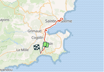
Croix Valmer - Ste Maxime A/R

fhascoet
User


6h00
Difficulty : Medium

FREE GPS app for hiking
 SityTrail
IGN / Geographical institutes
SityTrail Plus
The world is yours!
About
Trail Road bike of 45 km to be discovered at Provence-Alpes-Côte d'Azur, Var, La Croix-Valmer. This trail is proposed by fhascoet.
Description
passage dans Port Grimaud - montée au sémaphore de Ste Maxime
Bonne piste cyclable sauf au passage de l'echangeur de Cogolain plage où l'on est abandonné à notre triste sort au milieu des voitures (surtout problématique au retour) .
Positioning
Comments